Interdisciplinary project
Chairs/Institutions
IGP: Prof. Dr. Markus Rothacher; Structural Mechanics and Monitoring (IBK)
Leading professorship
Prof. Dr. Markus Rothacher ()
Further advisors
Prof. Dr. Eleni Chatzi ()
Yara Rossi ()
Dr. Roland Hohensinn ()
Project title
Structural monitoring of the Prime Tower: system identification and Kalman filter combination of accelerometer and GNSS
Abstract and work packages
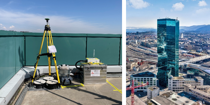
The Prime Tower is the second largest tower of Switzerland with 130 m height and situated in downtown Zurich. Recently, the IGP and SED have installed several monitoring instruments on the top of the tower, namely a GNSS antenna and an accelerometer. The height and location of the tower allows for a wide range of motions to be measured with these instruments: the vicinity to train tracks and strongly-frequented streets induces interesting high-frequency vibrations detectable with the quality-grade three-component accelerometer (EpiSensor, Kinemetrics). The wind will additionally induce periodic motions at lower frequencies that are detectable with GNSS. These events range from few micrometers up to 20 cm peak-to-peak displacements, which are expected to be seen during storm-like wind events. The tower is monitored during the windy time of April 2021, or a potentially longer period, which will result in a unique dataset. The students will analyze part of the month-long GNSS and accelerometer data and perform a system identification of the tower, which includes an eigenmode analysis of the building. The variations of the periodic building motions over time can be cross-correlated to the wind and temperature data of the Prime Tower weather station, in order to analyze and better understand the wind-induced building motion. Further processing includes a Kalman filter combination of the measurements of the different sensors in order to take leverage of the advantages of each instrument – this results in high-quality broadband displacement estimates, that can then be used for further analysis in structural monitoring and system identification.
Number of students per group (1-3)
1-2
Maximum number of groups
1
Language (incl. report, oral presentation and poster)
English or German
Chairs/Institutions
IGP, Mathematical and Physical Geodesy: Prof. Dr. M. Rothacher; Astrocast SA
Leading professorship
Prof. Dr. Markus Rothacher ()
Further advisors
Nicolas Steiner ()
Dr. Gregor Moeller ()
Yara Rossi ()
Project title
Calibration of the GNSS antennas mounted on an Astrocast nano-satellite using an industry robot
Abstract and work packages
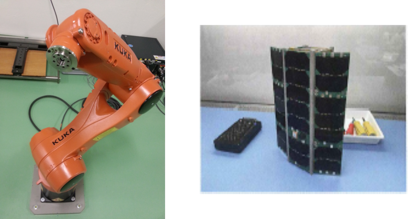
Motivation: The MPG disposes of an industry robot of the company Kuka (6 axes, 90cm range, 5kg payload, max. velocity 8.9 m/s, max. acceleration 36 m/s2). The robot has been carefully calibrated with terrestrial measurement techniques and can be used for the calibration of GNSS antennas. Of highest importance are the phase center offsets and variations of the two GNSS antennas located on the Astrocast nano-satellites, two of which have already been launched into orbit. A qualification model (QM) of such a 3-unit cube satellite is available and can be mounted on the robot. By rotating and tilting the satellite model with the robot it will be possible to derive the antenna phase center variations of the two antennas mounted on the satellite. The derived antenna patterns will be crucial to analyze the raw GNSS data collected on the short baseline between the two antennas.
Tasks:
1) Get familiar with the robot operations
2) Performing GNSS measurements on the roof of the HPV building with the satellite mounted on the robot.
3) Analysis of the GNSS phase data from the performed experiments with an existing software
Number of students per group (1-3)
1-2
Maximum number of groups
1
Language (incl. report, oral presentation and poster)
English or German
Chairs/Institution
Mathematical and Physical Geodesy (MPG): Prof. Dr. Markus Rothacher; Space Geodesy: Prof. Dr. Benedikt Soja
Leading professorship
Prof. Dr. Markus Rothacher ()
Further advisors
Prof. Dr. Benedikt Soja ()
Endrit Shehaj ()
Project title
Machine Learning for Orbit Determination
Abstract and work packages
Machine learning has become a hot topic for scientists in the recent years. The successful applicability of this technique in a large number of fields, has led scientist to investigate its potential also in other domains. Machine Learning can be used in a variety of space applications. With the increase of satellite missions and data, a huge amount of orbit determination (OD) data are available. Machine Learning (ML) can exploit those data to improve the orbit predictions of the satellites. Available broadcast ephemeris can be used to predict the orbits. The predicted orbits can then be compared to precise ephemeris from the International GNSS Service (IGS). Both orbit types are freely available for GNSS satellites, for instance.
Objective
In this project, the main goal is to investigate machine learning algorithm for the improvement of orbit predictions.
Tasks to be performed
1. Review of orbit determination.
2. Review state of the art of ML for OD.
3. Test case for OD (LEO, MEO or GEO); possible scenario simulation from STK.
4. CNN development for OD.
5. Test and performance analysis of ML for the OD prediction.
References
external page https://tutcris.tut.fi/portal/files/16540707/CNN_paper.pdf
external page https://link.springer.com/article/10.1007%2Fs40295-019-00158-3
external page https://ui.adsabs.harvard.edu/abs/2019AGUFM.G21C0753B/abstract
Number of students per group
1-2
Maximum number of groups
1
Language (incl. report, oral presentation and poster)
English or German
Chairs/Institution
Space: B. Soja; GSEG: A. Wieser; VAW: A. Bauder; PRS: K. Schindler
Leading professorship
Prof. Dr. Benedikt Soja ()
Further advisors
Dr. Gregor Moeller ()
Dr. Matej Varga ()
Raphael Moser ()
Prof. Dr. Andreas Wieser ()
Prof. Dr. Konrad Schindler ()
Project title
Development of a low-cost system for direct georeferencing of a helicopter-borne radar system
Abstract and work packages
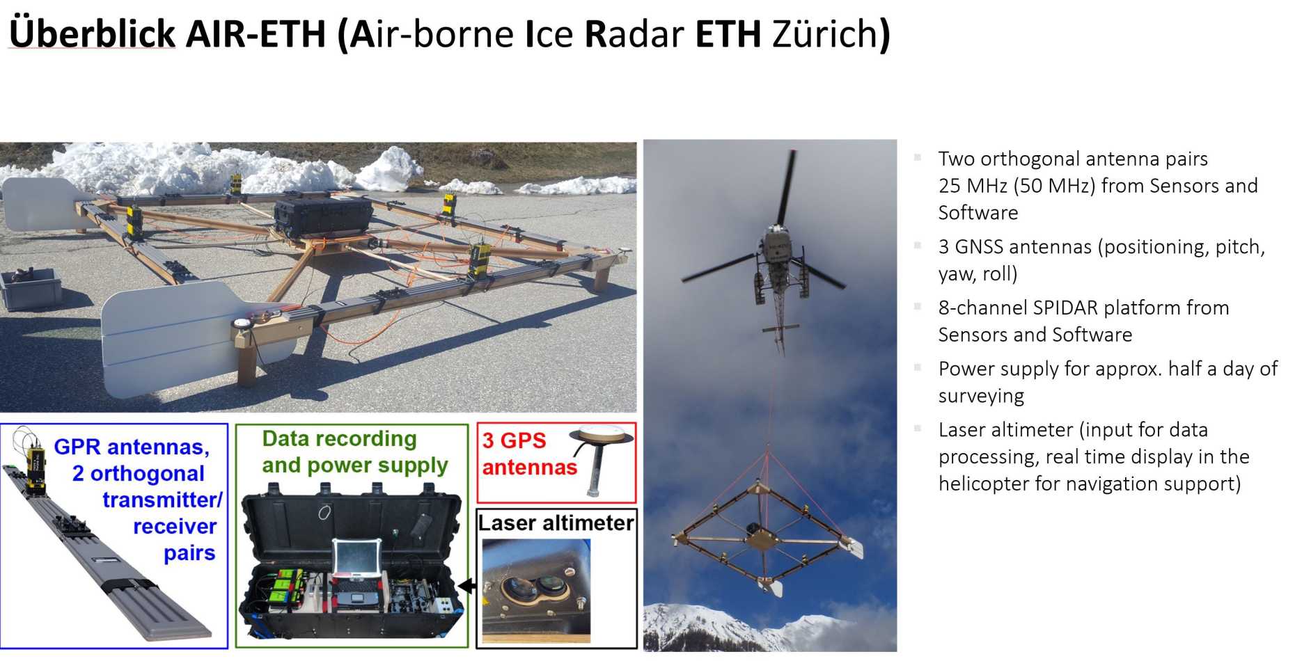
For the study of ice thickness and glacier structure, the Laboratory of Hydraulics, Hydrology and Glaciology (VAW) is seeking a low-cost GNSS/INS solution for direct georeferencing of their helicopter-borne ground-penetrating radar (GPR).
In this interdisciplinary project, you will get the chance to work on a development of a fully automatic georeferencing system for the operation in helicopter-borne measurement campaigns. The measurement system should be based on low-cost GNSS and Inertial Navigation System (INS) components. Thus, in an initial study, the high-rate (10 Hz) performance of the low-cost u-blox ZED F9P receiver is analyzed in combination with selected GNSS antennas to find a good setting for the intended kinematic use case. In a second step, the GNSS system is complemented by an INS (e.g. XSens MTi) for capturing the short-term variations and for GNSS outage bridging. The performance of the GNSS/INS system is tested on the Kuka robot using the angular readings of the robot as a reference. For the processing of the GNSS carrier phase measurements, a real-time kinematic (RTK) solution has to be set up using RTKLIB. For a loosely coupled integration of the INS, the existing Kalman-filter solution has to be extended for the determination of orientation parameters and modelling of INS sensor errors. As an optional extension, the potential of image-based georeferencing using photogrammetric techniques can be studied. After successfully testing, the developed georeferencing system is validated on a helicopter flight near Sion/Valais.
Number of students per group
1-3
Maximum number of groups
1
Language (incl. report, oral presentation and poster)
English


